


la thuile

Liebeaux
User
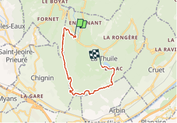

Length
12.6 km

Max alt
1292 m

Uphill gradient
764 m
Km-Effort
23 km

Min alt
783 m

Downhill gradient
669 m
Boucle
No
Creation date :
2021-05-27 07:23:16.556
Updated on :
2021-05-27 13:37:38.85
6h12
Difficulty : Very difficult

FREE GPS app for hiking
 SityTrail
IGN / Geographical institutes
SityTrail Plus
The world is yours!
About
Trail Walking of 12.6 km to be discovered at Auvergne-Rhône-Alpes, Savoy, La Thuile. This trail is proposed by Liebeaux.
Positioning
Country:
France
Region :
Auvergne-Rhône-Alpes
Department/Province :
Savoy
Municipality :
La Thuile
Location:
Unknown
Start:(Dec)
Start:(UTM)
268513 ; 5047761 (32T) N.
Comments